Wednesday, January 31, 2007

GI/GIS will be the spatial backbone for agricultural policy implementation and control

Mr. András Pásztohy, Ministerial Commissioner of MoARD emphasizes the importance of the introduction of map-based information systems in the follow-on actions. Image: HUNAGI Visuals resource, 2007
eFarmer - contribution to the main goals of Collaboration and Community Building

The Conference held at the HUNGEXPO Budapest Fair Center was chaired by Prof. István Fehér of the Szent István University (SZEI). The Opening and keynote address were delivered by András Pásztohy of MoARD, Prof. József Molnár, Rector of Szent István University, Michal Demes of FAO SEUR, Peter Wellisch, IACS project Manager of the Agricultural and Rural Development Agency (MVH), Attila Tóth, President of the International eFarmer Consortium, Johannes Keizer of FAO GILW at Rome and Tamás Bori of DG Agri of the European Commission.


On behalf FAO SEUR Michal Demes made recommendations for strategic partnership including e-Farmer Portal , ESCORENA Network and the FAO related thematic Knowledge Networks. He mentioned implicite the recently started talks with international and Hungarian communities in the field of spatial informatics, spatial data such as digital orthophotos and maps.

(See the entry spot of January 25 on this blog)
In the field of regional and national communication systems - the AgroWeb (AW) Network, he addressed issues in the V4 region (the so called Visegrád-Countries: CZ,HU,PL,SK) and emphesized the lack of sustainable personal contact and continuity and introduced the present priorities in order to support local AW portal managers and to strengthen the national coordinators in different expert fields. These territorial portals supporting knowledge sharing and cooperation in the Caucasus and Central Asia region and in the South-East-Europe region as well. This is the area which is on the priority list of the EUROGI WAG International Affairs ie. the extension towards the EU Neighbour Countries with special emphasis on the alignement of the spatial infrastuctures. (See map, courtesy by FAO AgroWeb)


Related sources:


More geospatial relevant messages of Peter Wellisch, Johannes Keizer, László Gábor Papócsi of SZEI (www.efarmer.net ) and Gábor Csornai, Head of the FÖMI Remote Sensing Center (www.fomi.hu ) will be given asap. It was good to see some HUNAGI members in the audience too. A dedicated two-page leaflet in English has been disseminated on the spot describing HUNAGI, the Hungarian Spatial Data Interest Community in nutshell.

Digital Earth Contest will be released soon!

Info is expected here on 1st February 2007
******************************
5th International Symposium on Digital Earth
Original news will be released by www.isde5.org
******************************

Monday, January 29, 2007

Secure, dependable and trusted Infrastructures and ICT in the 7FP

Elevated roads in Tokyo.
Image: HUNAGI Visuals resource, 2005

Information Day dedicated to ICT Challenge around infra-structures


From our today's mail


"Dear Colleagues,
* A flash update about the information day dedicated to ICT Challenge 1 - Call 1, including Objective ICT-2007.1.4 - ***Secure, dependable and trusted Infrastructures***
February 26, Brussels
This information day targets potential ICT proposers for the Challenge 1 objectives that are open in call 1, including Objective 1.4 - Secure, dependable and trusted Infrastructures.
In attachment (below), please find the agenda of the plenary session and of the parallel session on Objective 1.4.
More information and registration at:
http://cordis.europa.eu/fp7/ict/programme/events1-20070226_en.html
* Do also not forget the information day related to the whole ICT research in FP7 Work Programme for 2007-2008
February 1, Koln
Latest information at
http://ec.europa.eu/information_society/events/koln_2007/index_en.htm
Sincerely,
Jacques BUS Head of Security Unit DG Information Society and Media, ICT Programme European Commission
email: Jacques.BUS@ec.europa.eu tel: +32.2.296.81.16 fax: +32.2.296.83.64
Additional information about the Security unit can be found at
http://cordis.europa.eu/ist/trust-security/newsletter.htm "


Special thanks for Mr. Tamás Kolossa from Brussels for the update -

Saturday, January 27, 2007

eFarmer Central European Conference 2007

The HUNGEXPO Fair Area. Image: Google Earth, 2007
Central European Conference: eFarmer 2007
31 Jauary - 1 February 2007
HUNGEXPO EU-house (Building 25), Budapest
Conference organised under the auspices of DG AGRI, DG InfSo, MoARD and Office of Agriculture and Rural Development. Host institution: Szent István University
More information:
http://www.efarmer.org/conference/docs/Meghivo_eFarmerKonferencia2007.pdf
Topics covered are: IACS, Agricultural Parcel-based Information System (MEPAR), FAO's Agroweb services.
Numerous HUNAGI Member Institutions, Programs as well as partners from Hungary and abroad will participate.

Thursday, January 25, 2007

2nd Meeting of the UN SDI HUCOStakeholdres

Discussion room of the Hungarian Met Service, venue of the meeting.
Image: HUNAGI Visuals resource, 2007

Action Plan in the spotlight


A summary will be given asap.


Photos on the participants and presented slides of the Agenda and Proposed Action Plan can be found at www.hunagi.hu ....Photo collection.... Events in 2007..

Tuesday, January 23, 2007

CENTROPA Poster Exhibition with contributions from Hungary

Prof. Rudolf Giffinger (left) in background with the VATI poster.
Image: HUNAGI Visuals resource, 2007

Spatial Planning and GIS - an Exhibition


Opening ceremony including keynote movie followed by panel discussion attracted a large number of experts including Austria, Czech Republic, Germany, Hungary and Slovakia
The exhibition is open for the public free between 23 January and 9 February
Spin-off: informal AGEO-CAGI-HUNAGI talks during the reception involving representatives of Térinformatika and VÁTI

More photographs: at www.hunagi.hu ...Photo collection...Events

Thursday, January 18, 2007

AVA3 International Conference on Agricultural Economics, Rural Development and Informatics

AVA3 International Conference on Agricultural Economics, Rural Development and Informatics in Debrecen, Hungary 20-21 March, 2007

The conferece will take place at the Debrecen University, valued Member of HUNAGI.
According to Prof.Dr. Miklós Herdon, President of the Hungarian Federation of Agricultural Informatics (MAGISZ), papers are welcomed on GI/GIS applications/developments in the subject areas. The already extended deadline is the 2nd of February.

Detailed information on objectives, registration, subject areas, presentations, general info available at:
http://www.agr.unideb.hu/ava3/

More on MAGISZ (Hungarian Federation of Agricultural Informatics):
http://odin.agr.unideb.hu/magisz

Wednesday, January 17, 2007

Final text of INSPIRE approved following the conciliation process


The INSPIRE Clock starts ticking.

The final text for the INSPIRE Directive was approved in Brussels. This news was just received via the EUROGI newschain: specifically via Bruce McCormack, Conveyor of EUROGI WAG International Affairs. Roger Longhorn added important notices including: "this is the final text approved by the European Parliament and Council of Minsters, following the conciliation
process. The adoption of the Directive is an agenda item for theEuropean Parliament's meeting of 17 February 2007 in Strasbourg. "
The close range timetable of the follow-on actions include the official translations into the official EU languages and the publication in the Official Journal of the European Union probably about May. Meantime the discussion draft of some of the Implementation Rules will be circulated among the LMOs and SDICs for comments and remarks .

The full approved text in English is available here: http://www.fomi.hu/hunagi/pdf/2004/InspireEN.pdf

Friday, January 12, 2007

X-Border-GI 2007 Symposium

X-border-GI2007-Symposium in Dresden, 10 - 11 May, 2007
EUROPEAN WEEK 2007 - The 6th Saxonian GI Strategy-Forum
6. Sächsisches GI Strategie-FORUM in der EUROPAWOCHE 2007
[
http://www.sogi.ch/agenda.html#5 ]
[
http://egip.jrc.it/200612/1944.html ]
A joint X-border-collaboration of CAGI-CZ & IGN-SN in cooperation with EU-FP6-Project-NNR (NATURNET+REDIME)
OPEN CALL for papers/posters/demos ... t.b.a. =>> 15 January, 2007
>> GI2007 <<<>
[ mailto:info@GDI-SN.de?Subject=GI2007:__________ ]

GI Forum in Salzburg Call for Papers

Final Call for Papers!
Geoinformatics Forum Salzburg

The Geoinformatics Forum Salzburg (GI_Forum) will take place July 03-06, 2007, at Salzburg University, Austria. The information below was received via Prof.Dr.Béla Márkus, Dean, Faculty Geoinformatics, West Hungary University today. For more details please visit http://www.gi-forum.org/

Audience
GI_Forum focuses on an international audience that shares an interest in Applied Geoinformatics. This Call for Papers aims at researchers who design, develop and apply advanced methods and techniques of Geoinformatics to a broad range of application domains.
Themes & Application Fields
We solicit papers on emerging topics and research outcomes related to Geoinformatics methodology. The following is by no means an exhaustive list of symposium topics:
Geospatial data acquisition
Spatial analysis and knowledge extraction
Advanced visualisation and cartography
Distributed and mobile services
Dynamic modelling and simulation
Application fields comprise natural resources, health and environment, sustainable management of resources such as energy and water, transportation and infrastructure, participation and administration as well as security and emergency management.
Submission: Types & Deadlines
GI_Forum 2007 gives authors choices about the type of submission they want to make in order to accommodate a variety of interdisciplinary contributions. A submission must be written in English language according to the formatting guidelines.
Deadline for submission of full papers and extended abstracts for publication: 01 February 2007.
Late deadline for submission of extended abstracts for poster and/or oral presentation:27 April 2007.
We will only accept online submission
Online Submission under Call for Papers at
http://www.gi-forum.org/ or directly at:
http://www.agit.at/gi-forum/author/beitragsanmeldung/step1.asp?Conf=1
Publication
Accepted submissions will be published by Wichmann Verlag as a book.
We are looking forward to your submission!
Conference Chair: Josef Strobl
Programme Chair: Adrijana Car

office@gi-forum.org

Novel, global-level inter-organisational action of HUNAGI and Térinformatika

An interesting trial addressing the spatial data management communities worldwide

Masterminded by the Editor-in-Chief of the Hungarian geospatial journal Térinformatika Dr. Szilár Szabó, a set of short questions on a specific, future related topical application of GI/GIS was circulated worldwide using HUNAGI's links with acknowledged European and Global organisations and associations yesterday. Lets' make the subject cleared after HUNAGI will approached by the first boomerang coming from any of the involved international organisation (expected soon, probably in the coming hours). The evaluation of the entries will be made by Térinformatika but as a spin-off result, also the methodological effectiveness such an inter-organisational approach will be investigated by HUNAGI taken into account all measurable aspects including geospatial distribution of the interested parties. Anyway, the first positive feedback cames from the direction of UNGIWG, which is more than promising.

Thursday, January 11, 2007

Call for Papers - ISDE-5

Downtown San Francisco with Berkeley in the background. Image: HUNAGI Visual resources, 2003. Courtesy by drSB
The latest news on the 5th International Symposium on Digital Earth

Date and Venue: June 5-9, 2007, Berkeley, San Francisco Bay Area, USA

Important dates:
February 28, 2007
Deadline for acceptance of proposed presentations and papers.
March 15, 2007
Notification to authors of accepted presentations and papers.
April 1, 2007
Regular registration fees deadline.
April 15, 2007
Deadline for authors to submit final paper (completed manuscript).

April 15, 2007
International Digital Earth Mash Up Competition Deadline.
June 5th 2007
Opening Ceremony - 5th International Symposium on Digital Earth."

For further details and authentic updates please visit: http://www.isde5.org

Please note, HUNAGI representative is member of the Organising Committee, the Hungarian presence is encouraged. HUNAGI is actively participated the ISDE since 2003 and submitted bids to host the next venueof the biannual event in two times. First Tokyo was won. Second time our step back was a support for San Franciso with the anticipation to host the next event in 2009.

International Society for Digital Earth
"In an unprecedented move by the Chinese government, a non-profit entity from the Chinese Academy of Sciences was created to host the international secretariat that would help with governance and promotion of the International Symposium on Digital Earth. The inaugural International Society for Digital Earth meeting was held May 21-22, 2006 in Beijing attended to by the President of the Chinese Academy of Science, Dr. Lu and the Chinese Minister of the Ministry of Science and Technology, Dr. Xu, along with 16 renowned international experts . This historic meeting marks the creation of the first sustained international governance organization supporting the Digital Earth vision.
The name of the newly formed organization is the "International Society for Digital Earth”, hereafter referred to as ISDE. ISDE is a non-political, non-governmental and not-for-profit international organization founded by the Chinese Academy of Sciences." (TF)

For more information on ISDE click here
Chinese Press Release on ISDE click here
Sources: Embassy of Republic of China in Bucarest and Dr. Thimoty Foresman, Director of ISDE 5

Wednesday, January 10, 2007

UN SDI Global Partner Meeting hosted by the European Space Agency

Excellent opportunity to make both European and Hungarian achievements visible for the rest of the World with special emphasis on the Developing Countries
Invitation letter from UNGIWG received today. UN SDI HUCO stakeholders will be informed on the details asap. Other HUNAGI Members and interested third parties will be informed in e-Newsletter 2007-3 released in one week or so. For further inquiries please write to hunagi@hunagi.hu
NEW! Preliminary program as of January 10, 2007 compiled by J.U.Hielkema is available here
For more information related to the reform of the UN click here
Source: UNGIWG

Tuesday, January 09, 2007

Hungarian presence at the Exhibition on Spatial Planning and GIS in Central Europe


International Poster Exhibition in Schwechat, Austria devoted to Spatial Planning and GIS organised by AGEO, CAGI, CEIT, CENTROPA and CEIT ALANOVA.
HUNAGI Delegation invited to take actively part

Opening Meeting on January 22. Duration of the Exhibition: January 23-February 9. HUNAGI made immediately an announcement on Call for Posters in Hungarian at http://hunagi8.blogspot.com with some direct mails to potential poster presenters from the HUNAGI community including VÁTI, Dept of Landscape Planning at the CORVINUS University, Szombathely City Hall, FÖMI, NKP Kht, GEO Faculty of the West Hungary University and InterMap Ltd.
The City Hall of Schwechat, venue of the Poster Exhibition between 23rd January - 9th of February. Image courtesy: www.schwechat.gv.at
So far four Hungarian poster contributions were offered by four institutions as follow:

"RURAL DEVELOPMENT CONCEPT AND SPATIAL PLAN OF THE TISZA REGION" (2 posters DIN A0)
Project leaders: Annamaria Göncz, Kornélia Fogarasi
Institution: VÁTI Hungarian Public Nonprofit Company for Regional Development and Town Planning, Department of Spatial Planning, Budapest, Hungary (www.vati.hu )

"INTEGRATED USE OF DIGITAL ORTHOPHOTO AND VECTORISED DIGITAL CADASTER WITH COUNTRY COVERAGE IN SPATIAL PLANNING" (one poster DIN A0)
Project leaders: Peter Winkler, Gyula Iván, Attila Váczy
Institutions: FÖMI in conjuction with the National Cadastre Program Public Nonprofit Company (NKP Kht.) Budapest, Hungary ( www.fomi.hu , www.nkp-kht.hu )

WATER RESOURCES MANAGEMENT IN PROTECTED AREAS 2006-2008, WAREMA Project. Interreg III B CADSES. Authors: international team. Hungarian contact: Ms.Margit Horosz-Gulyás, Dept. of Land Management, Faculty of Geoinformatics, West Hungary University 8000 Székesfehérvár, Pirosalma u. 1-3. Tel: +36 22 516 582 E-mail: hm@geo.info.hu www.geo.info.hu

Sunday, January 07, 2007

UNSDI.hu linked from the UNSDI.EU portal


Internet startpage of the UNSDI HUCO linkeable from the UNSDI European portal

Mr. Jan Cees Vanema, Head of the UNSDI Coordination Office for The Netherlands announced today the just established link from the European UNSDI Portal to the Hungarian partner office's website www.unsdi.hu hosted by WEBhu Ltd.
It is anticipated, the startpage will be upgraded soon to a more advanced website environment to be operated remotely by content management software such as Liferay, Plone, Joomla or WebtoDate. The selection will be made in close consultation with the host service provider and with our UNSDI EU partners.

Saturday, January 06, 2007

UN SDI HUCO's internet startpage is operational

Internet startpage of the Hungarian Coordination Office of the United Nations Spatial Data Infrastruc- ture Pilot launched at www.unsdi.hu

The startpage is hosted by the WEBhu Ltd, Member of HUNAGI. Webmaster is Mr. Bela Gyuricza. The same company provides startpage of the Hungarian Association for Geo-information as well. More information on the Internet oriented service provider:
www.webhu.hu

Friday, January 05, 2007

2nd Stakeholder Meeting of UNSDI HUCO scheduled for 25th January 2007

The HQ of the Hungarian Meteorological Service in Buda Image: HUNAGI Visuals Resource, 2006


Hot topics on the agenda of the meeting hosted by the Hungarian Met Service
25 January, 2007, Thursday 2 p.m.
Venue: OMSZ HQ
Budapest II. Kitaibel Pál utca 1

By invitation only!

Preliminary programme (translation will be completed later today):
- adoption of the preliminary agenda and overview of the developments of the past four months in the UNSDI HUCO relevant context (incl. UNGIWG-7, GSDI Board Meetings, GSDI9, EUROGI EMM, INSPIRE-UNSDI Meeting) ,
- The HUCO approach was selected as model to be presented at the UNSDI Global Partner Meeting scheduled for early March in Frascati hosted by ESA. Preparation of the enhanced presentation taking into account the guidelines of the UNGIWG. Contribution of the stakeholders, recommendations and discussion,
- prioritysed hot issues in the SDI context from the aspects of the economy/market, public services, education and reserarch,
- State of the art and actions to be taken related to the SDI strategy, INSPIRE taking into account the potentials of the National Development Operational Programs and the short term tasks of the Hungarian LMOs (FÖMI and Hung Met Service) as well as SDIC (HUNAGI) in association with the reviewing of the INSPIRE implementation rules released by the European Commission soon (with very short feedback time),

- Expectations, potentials expressed and contributions offered by the stakeholders to support UN SDI HUCO operations and HUNAGI as backing association of the wider GI community
- Summary of resolutions, actions to be taken and publication of a press release

Recommended background documents for the invited stakeholders:
INSPIRE latest available version http://inspire.jrc.it
INSPIRE implementation rules (if available at 25th January) http://sdi.jrc.it
SDI Cookbook 2nd Edition November 2006 http://www.gsdi.org
UNSDI Vision & Strategy (FAO) 2006 november http://www.ungiwg.org

Geospatial Information for the Sustainable Development (UNGIWG) 2006 http://www.ungiwg.org
National Development Plan http://www.nfh.hu
Operational Programs of the Implementation of the Information Society http://www.meh.hu (tbc)
Other recommended documents recommended by the stakeholders using hunagi@hunagi.hu ,
Best practices, examples: from Australia (governmental geospatial policy), Chile (Internet based imagery assisted service for territorial planning and analysis), Spain (governmental data policy and Local Governmental applicatuions using Open source tools) and Germany (intergovernmental coordination on federal level). Links will be provided asap.
Information will be given on the site on the activities of the EUROGI WAGs with special emphasis on the WAG International Alliance and potentials of synergy with INSPIRE and UN SDI.

The member institution representatives of the UN SDI Hungarian Coordination Board will be invited by Dr. Zoltán Dunkel, President of the host institution Hungarian Meteorological Service.

Tuesday, January 02, 2007

e-Newsletter 2007-1 with Calendar of Events

Header of the HUNAGI-UNSDI HUCO e-Newsletter Image: HUNAGI Visuals resource, 2007


The first issue of HUNAGI-UNSDI HUCO electronic Newsletter has been circulated

by e-mail for HUNAGI member institutions, student members and contacts of the extended mailing list of HUNAGI.
This thematic issue contains chronological listing of professional events and conferences of the coming months.

To subscribe please write to hunagi@hunagi.hu with the subject "eNewsletter: Yes please"
To unssubscribe please write to hunagi@hunagi.hu with the subject "No thank you"Calendar of events and conferences selected by HUNAGI and its partners. Contributions, enhancements are welcomed anytime. Please write to hunagi@hunagi.hu with Events int he subject line.

Sources and Contributors include FIG, ISPRS, GSDI, EUROGI, CEOS WGISS, UNSDI, European Commission, HUNAGI Members and Partners.


Events in Hungary (marked with bolded green) are collected and maintained by HUNAGI in partnership with Térinformatika, the Hungarian Journal on spatial informatics.


This listings is valid as of January 12, 2007 and will be not maintained.
The continuously updated and enhanced HUNAGI-UNSDI HUCO listing of Events and Conferences you can simply click on the main header title on the top of this spot

Please note 2007-2008 : The Electronic Geophysical Year (eGY) (eGY participants includes: ICSU, CODATA, World Data Centers, GeoUnions, National Academies of Sciences and others). More info: itt/here
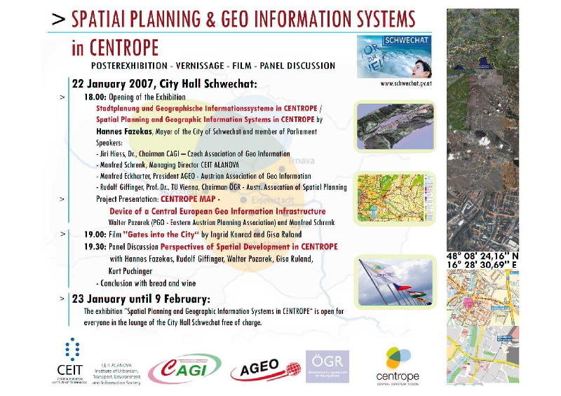
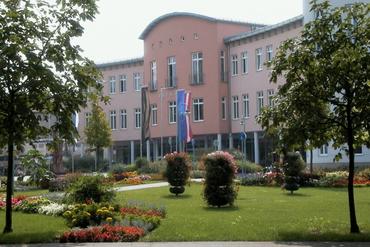
22 January 2007
Exhibition
More details asap
Schwechat, Austria

25 January 2007
2nd UNSDI HUCO Stakeholders' Meeting
hosted by the Hungarian Meteorological Service
(Working language: Hungarian)
More info soon at
http://www.unsdi.hu/ or http://hunagi.blogspot.com/
Budapest, Hungary


22-25 January 2007
Map World Forum,
http://www.mapworldforum.org/
Hyderabad, India

28-31 Jan 2007
GIS Ostrava 2007
First meeting of Czech and Slovak users of GRASS and other FOSS4G software
More
Ostrava, Czech Republic

1 March 2007

VI. Nagykanizsa GIS Conference
(Working language: Hungarian)
Nagykanizsa, Hungary


14-16 Feb 2007
GRASS and GFOSS Users Meeting
More
Palermo, Italy


7th International Geomatic Week
Globalgeo Technical Exhibition
http://www.setmana-geomatica.org
Barcelona, February 20 to 23, 2007

27-28 February 2007
ESA-FAO-JRC Plenary Workshop on the ESA Heterogenous Missions Accessibility (HMA)
http://www.esa.int/
Frascati, Italy

1-2 March 2007
First UNSDI Global Partners Meeting
http://www.ungiwg.org/
Frascati, Italy
1-2 March 2007
Intergeo East
http://www.intergeo-east.com/
Sofia, Bulgaria

5-7 March 2007
Open Source GIS Users Meeting
http://grass.itc.it/
Girona, Spain
7-9 Mar 2007
INTED2007 (International Technology, Education and Development Conference)
http://www.iated.org/
Valencia, SPAIN

12-14 March 2007
GIS Open 2007
(Working language: Hungarian)
http://gisopen.geo.info.hu/
Székesfehérvár, Hungary


March 17–19, 2007

ESRI Worldwide Business Partner Conference
www.esri.com/events/bpc/index.html

Palm Springs, USA

March 19–22, 2007

ESRI Developer Summit
www.esri.com/events/devsummit/index.html

Palm Springs, USA

20-23 Mar 2007

International Workshop on Volcanism and Tectonics
Details
Havana, CUBA

21-23 March 2007
3rd Asian Space Conference 2007
http://pdcc.ntu.edu.sg/ASC2007/
Singapore

28-31 March, 2007
FIG Commission 3 Annual Meeting and Workshop on Spatial Information Management towards Legalizing Informal Urban Development
http://www.fig.net/events/2007/comm_3_annual_meet_2007_call.pdf
Athens, Greece

30 March – 4 May, 2007
5th Meeting of the Committee on Development Information (CODI-V)
„Employment and the Knowledge Economy”
http://www.uneca.org/
Addis Ababa, Ethiopia

11-13 Apr 20074th IEEE GRSS/ WG III/2+5, VIII/1, VII/4 Joint Workshop on Remote Sensing & Data Fusion over Urban Areas; 6th International Symposium on Remote Sensing of Urban AreashereParis, FRANCE

11-13 April 2007
5th Easter European e-Gov Days
More

19-20 April 2007

Műszaki Térinformatika Konferencia
Geospatial Technology Conference
(Working language: Hungarian)
Műszaki Térinformatika Egyesület
http://www.gita.hu/
Debrecen, Kölcsey Központ, Hungary


April 23–25, 2007
ESRI Business GeoInfo Summit
www.esri.com/events/geoinfo/index.html
Dallas, USA

25 to 27 April 2007
UN/Morocco/ESA International Workshop on the Use of Space Technology for Sustainable Development
Source: UNOOSA-STD Sharafat.GADIMOVA@unvienna.org
More: Rabat, Morocco
http://www.unoosa.org/oosa/en/SAP/rs/index.html

25-27 Apr 2007
3rd International Exhibition & Scientific Congress on Geodesy, Mapping, Geology, Geophisics, Cadaster
"GEO-SIBERIA 2007"
http://www.geosiberia.ssga.ru/
Novosibirsk, RUSSIA


7-17 May 2007ASPRS 2007 Annual Conference "Identifying Geospatial Solutions"
here
Tampa, FL, USA

8-10 May 2007
Sustainable Neighbourhood – from LisSOURCEbon to Leipzig through Research (L2L)
„A conference on research for sustainable development in Europe” Federal Ministry of Education and Research (BMBF) in cooperation with the Fraunhofer Gesellschaft, Helmholtz Association of German Research Centres, Leibniz Association and Max Planck Society
CALL FOR PRESENTATIONS AND POSTERS [ http://www.fona.de/de/3_akteure/forum_2007/index.php?do=print〈=eng ] [ http://www.fona.de/de/3_akteure/forum_2007/pdf/L2L_Call_Short.pdf ] [ http://www.fona.de/de/3_akteure/forum_2007/pdf/L2L_Call.pdf ] [ http://www.fona.de/de/3_akteure/forum_2007/form/061120_application_exhibition_L2L.rtf ]
Leipzig, Germany


10-11 May, 200 7

X-border-GI 2007-Symposium EUROPEAN WEEK 2007 - The 6th Saxonian GI Strategy-Forum 6. Sächsisches GI Strategie-FORUM in der EUROPAWOCHE 2007
[ http://www.sogi.ch/agenda.html#5 ]
[ http://egip.jrc.it/200612/1944.html ]

A joint X-border-collaboration of CAGI-CZ & IGN-SN in cooperation with EU-FP6-Project-NNR (NATURNET+REDIME) OPEN CALL for papers/posters/demos ... t.b.a. =>> 15.01.2007 !!! -- >> GI2007 <<< href="mailto:info@GDI-SN.de?Subject=GI2007">info@GDI-SN.de?Subject=GI2007

Dresden, Germany

8-11 May 2007
10th AGILE International Conference on Geographic Information Science
'The European Information Society: Leading the way with geo-information'
http://www.agile-online.org/
Aalborg, Denmark

13-17 May 2007
FIG Working Week and General Assembly
Theme: Strategic Integration of Surveying Services
http://www.figww2007.hk/
Hong Kong SAR, China


15-16 May 2007
XIII. international conference Information systems in agriculture and forestry
Themed Living Labs
http://www.iszl.cz/
Prague, Czech Republic

20-23 May 2007
REAL CORP 007
12th international conference on Urban Planning, Regional Development and Information Society,and 2nd International Vienna Real Estate Conference and GeoMultimedia007
Tech Gate, Vienna, Austria

21-25 May 2007
CEOS WGISS 23
http://wgiss.ceos.org/
Hanoi, Vietnam

23-25 May 2007
Gi4DM, 3rd International symposium on Geo-information for
Disaster Management
https://www.cig-acsg.ca/cig2007/
Toronto, Canada
The symposium Gi4DM is recognised as the main international event by the Disaster Ad-hoc Group of The Joint Board of Geospatial Information Societies (JBGIS= IAG+FIG+IHO+ISPRS+ICA+ISCGM)

24-25 May 2007Effective and Sustainable Land Management.UNECE WPLA Workshop
here
Munich, Germany
29-31 May 2007
1st National GIS Conference
http://www.cagi.cz/
Mikulov, Czech Republic

28-31 May 2007
ISPRS IC WG I/V+V/I, WG I/2+3 5th International Symposium on Mobile Mapping Technology (MMT2007)
http://www.cirgeo.unipd.it/cirgeo/convegni/mmt2007/index.html
Padua, ITALY

4-7 Jun 2007
27th EARSEL Symposium Geoinformation in Europe
http://milano.irea.cnr.it/EARSeL/index.html
Bolzano, ITALY

5-8 June, 2007
5th International Symposium on Digital Earth,
Details
San Francisco, USA


7-9 June 2007
FIG Commission 2 Workshop – Scientia Est Potentia – Knowledge is Power
http://geoinformatics.fsv.cvut.cz/
Prague, Czech Republic


13-15 June 2007ISPRS WG II/7 Workshop - 5th International Symposium on Spatial Data QualityhereEnschede, the NETHERLANDS


ESRI Education User Conference
June 16–19, 2007 ·
www.esri.com/events/educ/index.html
San Diego, USA

ESRI Survey & Engineering GIS Summit
June 16–19, 2007 ·
www.esri.com/events/survey/index.html
San Diego, USA

ESRI User Conference
June 18–22, 2007 ·
www.esri.com/events/uc/index.html
San Diego, USA

2-5th July 2007
European Federation of IT in Agriculture 2007 Conference
EFITA/WCCA 2007
Glasgow Caledonian University, Scotland, UK

4-6 July 2007
13th EC GI & GIS Workshop
www.ec-gis.org/Workshops/13ec-gis/index.cfm
Porto, Portugal

18-20 July 2007
4th Bi-annual International Workshop on the Analysis of Multi-temporal Remote Sensing(MULTITEMP-2007)
Details
Leuven, BELGIUM

4-10 Aug 2007
22nd International Cartographic Conference
http://www.icc2007.com/
Moscow, Russia

20-24 Aug 2007
GeoNorth2007 Conference
here
Yellowknife, N.W.T., Canada

3-7 Sep 2007
51st Photogrammetric Week 2007
here
Stuttgart, GERMANY

19-23 Sep 2007
Conference on Spatial Information Theory (COSIT)
here
Melbourne, AUSTRALIA

2-5 October 2007
GeoCongress Quebec 2007
http://www.quebec2007.ca/
Quebec City, Canada,

10-12 October, 2007
26th UDMS 2007
University of Applied Sciences,
http://www.udms.net/
Stuttgart, Germany

29 October – 1 November 2007
9th South East Asian Survey Congress incorporating FIG Commissions 4 and 5 workshops,
www.surveyors.org.nz/congress2007
Christchurch, New Zealand,
6th FIG Regional Conference, San Jose, Costa Rica, 12-15 November 2007
Read more: http://www.fig.net/

12-14 December 2007
3D GeoInfo '07 & 2nd International Workshop on 3D Geo-Information
http://www.3d-geoinfo-07.nl/
Delft, The Netherlands

21-25 April 2008
Conference on Transport Research Area
http://www.traconference.com/
Ljubljana, Slovenia

Geographical distribution of the visitors of the HUNAGI-UN SDI HUCO newsblog during the past 6 monthsImage: HUNAGI Visuals resource, 2007


Monday, January 01, 2007

Updated folder in English: HUNAGI in Nutshell


Downloadable folder on HUNAGI

at the HUNAGI site

www.hunagi.hu

About us.... Leaflets

or here:

http://www.fomi.hu/hunagi/pdf/2004/about/leaflet/Leaflet7jan1.pdf

Bulgarian and Romanian GI Communities, welcome to the EU!

Bulgaria and Romania joined the European Union by January 1, 2007!
Excellent chance also for the geospatial communities of the two countries to forge closer links eg. to EUROGI, the European Umbrella Organisation for Geographical Information, where working and advisory grooups (WAGs) are active in the topics data access, applications, GI users, communications and international affairs in GI. This latter (WAG IA) has the mandate to provide assistance for the EU Neighbour countries in the field geographic information by networking, co-operation and exchange of information. The EUROGI WAG IA Action Plan will be released very soon.
More on the
http://www.eurogi.org
Similarly, the Hungarian Co-ordination Office of the United Nations Spatial Data Infrastructure initiative provides news at http://unsdihu.blogspot.com on the Hungarian spatial data interest community in English, which might be interesting for relevant communities of some Eastern European and Balkan countries. Consultations have been started to harmonise actions and developments in INSPIRE and UN SDI initiative. between the relevant unit of the European Commission and the United Nations GI Working Group. Countries such as The Netherlands, Germany, Czech Republik, Spain and Hungary are playing active role in the process.


The Spatial Data Interest Community of more than 100 Member Institutions


Hungarian Association
for Geo-information
hunagi@hunagi.hu
www.hunagi.hu
tel:+36 30 415 8276

Add me to your address book
Name:

Szakmai önéletrajz (2019.szeptember 9): https://eu1.documents.adobe.com/public/fs?aid=CBFCIBAA3AAABLblqZhCxAu-jWxUHiz2xXAQEQW-hazhHPwo4Qa1zsOyuvS6N3OhX6hjjqGLoZ8XljtLgF7A%2A

Geo Visitors Map
eXTReMe Tracker