Wednesday, October 31, 2007

Preparatory works on the Hungarian contribution of IYPE

Chaired by Dr. Károly Brezsnyánszky, the National Committee on the International Year of the Planet Earth held its 2nd meeting hosted by the Hungarian Academy of Sciences.
Preparation of the Opening Event was the major issue addressed. HUNAGI and its member institutions and organisations will be informed soon how to contribute.
International website:
http://www.yearoftheplanetearth.org/
Hungarian website:
http://www.iype.hu/


Notice: This HUNAGI Newsblog was visited between October 1-31 by 1077 visitors from 86 countries. Breakdown: Hungary 17,7% USA 11,1% Romania 8,7% Germany 5,9% UK 4,2%.

This HUNAGI Newsblog had 6141 visitors between 2 August 2006 to 3 August 2007. The ClustrMaps illustrates the global geographical distribution. Governmental agencies, parliaments, global organisations, NGOs, universities and colleges as far as the private sector were identified among the visitors.

Further HUNAGI blogs include the Newsblog in Hungarian at http://hunagi8.blogspot.com and some thematic ones e.g. Calendar. The HUNAGI Visual resources at www.hunagi.hu (Photo collection), http://picasaweb.google.com/hunagi.hu, http://picasaweb.google.com/gabor.remetey as well as http://hunagi18.blogspot.com are also frequently visited.

Tuesday, October 30, 2007

Professor Dr. Ernst Messerschmidt, German Astronaut in Budapest

Prof. Dr. Ernst Messerschmidt listen the question after his presentation at the ELTE in Budapest. Image: HUNAGI Visuals resource, 2007


The knowledge knows no bounderies...


Former German Astronaut and Professor of the University of Stuttgart, Dr. Ernst Messerschmidt delivered a lecture during his visit in Budapest. The event was organised by the Vice-Rector of ELTE and Chair of Cartography and Geoinformatics Prof. Dr. László Zentai.


The Hungarian Astronaut Bertalan Farkas introduced a NASA video on the International Space Station. In the discussion part Prof.Messerschmidt expressed his view about the importance of knowledge and capacity building.


Saturday, October 27, 2007

EUROGI EMM 2007 held in Lisbon


Autodesk, ESRI Europe, NAVTEQ and Intergraph on the Board representing the private sector in Europe.
AGI will leave by 31 December. Ihlet has been acknowledged . The WAG International Affairs were presented by Bruce McCormack including the activities in Eastern Europe. Ihlet's Workshop in Brussels was explicite mentioned and evaluated as a good start but a lot to do. He circulated his contribution to the successful meeting organised by the Embassy of South Africa in Brussels entitled "Geoinformation in development cooperation: towards a policy and implementation framework". That meeting was attracted organisations such as the European Commission (AIDCO, DG Research, DG Development), UN (UNGIWG, WHO, GEOSEC), USAID, JICA, EUROGI, EIS Africa, Universities, Embassies of Nigeria, South Africa and Kenya as far as National GI Associations as IRLOGI and AFIGÉO. (HUNAGI was not able to participate due to the schedule conflict with HUNAGI FORUM held on the same date. ) The Data WAG related issues presented by Sandro Gizzi were also discussed.
After EUROGI the ExCom Meeting, President Prof. Mauro Salvemini introduced his new vision related to the reshaping, restructuring of EUROGI in order to strengthen its influence and acknowledgement.
Secretary General Joao Geirinhas made in-depth overview on the activities of the Organisation.
The host institution made excellent arrangement both in professional content and the Meeting-related logistics. Superb presentations were delivered by Professor António Camara of YDreams on Trends and new visions, followed by Anabela Pedroso of the Agency for the Administrative Modernisation who addressed the e-Government related aspects, finally by António Arnaud of the New University of Lisbon, who introduced the European project "Addresses", which is participated also by Hungary via FÖMI.
The host institution Portuguese Geographic Institute was also introduced by Deputy Director General Rui Pedro Juliao, the SDI by Danilo Furtado, while the market implementation was dealt by Dirk Tilsner of EDISOFT. In the Members' Session, HUNAGI made also contribution in line with the pre-circulated questionnaire and using the EUROGI ppt-template. www.fomi.hu/hunagi/pdf/2004/EMM2007HUNAGI.pdf
All the contributions will be evaluated and synthetized and the outcome will be streamlined by a team of four (IRLOGI, SNIG PT, Autodesk and ESRI Europe).
More news with references will be added asap.

Thursday, October 25, 2007

Full House at the Annual ESRI Hungary User Conference

Prof.Dr.Bela Markus, Nick Land of ESRI Europe and Dr.Szabolcs Mihály DG of FÖMI. Image: HUNAGI Visuals Resource, 2007
Text will come soon. Please visit also www.unsdi.hu for further reports.

Friday, October 19, 2007

GSDI/HUNAGI presentation given at the WGISS-24


GEOSS Tasks involvements presented

Yesterday the meeting was devoted to the WGISS contribution to GEO, but also some liasion reports have been presented including ICU, CODATA, CCSDS and eGY. Today the series was continuing wth presentations of the host institution DLR, NASA, GSDI, JAXA, the Chinese NRSC and Thai Agency GISTDA, NOAA, USGS and GFZ.
The GSDI presentation is accessible at

www.fomi.hu/hunagi/pdf/2004/GSDIliasionReport.pdf , but all information related to this meeting can be found at the authentic website of the CEOS WGISS : http://wgiss.ceos.org

Wednesday, October 17, 2007

Grid Processing and Sensor Web

The 2nd working day of the CEOS WGISS-24 was almost entirely devoted to the enabling advanced technologies related to grid processing and sensor web developments including real applications as Tisza river monitoring in Ukraina-Slovakia and the Frascati Living Lab.

Monday, October 15, 2007

24th Meeting of CEOS WGISS started today

Building of the Management of DLR, venue of the Meeting. Image: HUNAGI Visuals resource, 2007

Nearly 40 experts from all over the world representing regional and national space agencies, academia, prime contractors and organisations such as GSDI Association came together in Oberpfaffnhofen, Bavaria to attend the 24th Meeting od CEOS WGISS.
Te hst institution is the largest R+D institution in Germany having a staff about 5200 among them 2500 scientists and 500 *hd students. The Meeting was opened by Chair Ivan Petiteville of ESA ESRIN and Günther Schreier of DLR.
Bernd Ritschel delivers his presentation on the challenge related to ensure data sustainability. Image: HUNAGI Visuals resource, 2007
More will come soon.

Sunday, October 14, 2007

Al Gore and the UN IPCC share the 2007 Nobel Peace Prize

Albert A. Gore and the UN Commission on Climatic Change (IPCC) won the 2007 Nobel Prize for Peace
Al Gore's vision was the basics the Digital Earth initiatives having a series of international symposia in Beijing, Canada, Brno, Tokyo and Berkeley, Calif. HUNAGI joined in 2003 in Brno to the community and today keeps excellent working relation with the prominent International Society of Digital Earth established in Beijing in 2006 by the support of the Chinese Academy of Sciences and the international Digital Earth community.
Please search for the keywords Digital Earth and HUNAGI on the Internet.
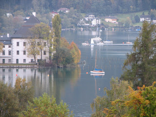
Now, just travelling to Ober-pfaffenhofen to attend the 24th CEOS WGISS Meeting hosted by the German Aerospace Center DLR stopover was made in Seewalchen am Attersee to put this spot on the blog.
More on the WGISS and the relation with the global/regional and local spatial data infrastructure soon on these pages.

Friday, October 12, 2007

GISIG - established just 15 years ago

HUNAGI is member of GISIG since the mid of the 90's.
From our daily mail - Giorgo Saio wrote today:
"Dear GISIG Members,
Today is a special day for the Association: on October 12th 1992 (more less at this hour) GISIG has been formally constituted :-)We are then celebrating 15 years of life of the Association.We wish to take this opportunity to thanks all the Members that during these years have contributed to the development and success of our Community =D>We are then very pleased in inviting all of you to participate to a series of events scheduled in Genoa next 21-23 November: we are referring to the presentation of the VESTA-GIS project, to the GISIG Assembly and to the ECO-IMAGINE Conference.VESTA-GIS (apologies for the VESTA-GIS partners that already received this communication)We are very pleased to inform you about a new Leonardo da Vinci networking project within the Lifelong Learning Programme: "VESTA-GIS: Vocational Education and Sectoral Training network on GI & GIS Application domains".The expected starting date of VESTA-GIS is November 1st, 2007, for a duration of three years. As you might remember (see our invitation (of last March) to participate in the project), VESTA-GIS reflects the scheme applied within former training and education programme, promoted by GISIG from the initial project for a COMETT UETP (University-Enterprise Training Partnership) which brought to the constitution of GISIG, to arrive to the latest Leonardo projects, including people mobility and networking activities.With this new initiative we intend to renovate such a successful scheme within the new LLP - Leonardo da Vinci Programme which foresees a specific action for Thematic Networks, aiming to pool knowledge in GIS specific domains, to share experience and foster innovation (new approaches) in GIS vocational training. VESTA-GIS and the related tasks will be developed in a Training Framework structured into three leading GI thematic domains, subject of the Thematic Network promoted in these last years by GISIG (Water resources management, Coastal management and Landscape and Natural Environment Protection). That in addition of course to training on GI technologies. VESTA-GIS is an open network : those of you who did not yet join the partnership are welcome as well. At this purpose, please find attached some outlines about the VESTA-GIS project together with (if you are interested in), the adhesion form to join the network. Taking the opportunity offered by the ECO-IMAGINE final Conference "FUTURE PERSPECTIVES OF GI FOR ICM" focused on one of the above leading thematic domains (Coastal Management), we are going to organise a first VESTA-GIS event as a dedicated session during the first day of the Conference on 21st November 2007 (see below the announcement). Please check also your possible interest to apply for the Marie Curie grant for the Conference (deadline October 28th). GISIG General AssemblyPlease take note that after the VESTA-GIS session we will continue with the GISIG General Assembly , and the celebration of the 15th anniversary of the GISIG constitution (1992-2007)..You will receive soon the official convocation of the Assemblyand the Agenda.We are very pleased in inviting all of you to these events.For organizational reason, we kind ask you to confirm your participation replying this message within October 31st. Looking forward to meeting all of you in Genoa next November 21st.Kind Regards Giorgio Saio

Dear friends/colleagues,
We are pleased to remind you the ECO-IMAGINE Final Conference:
FUTURE PERSPECTIVES OF GI FOR ICM Genoa (IT), November 21st - 23rd, 2007.On the ECO-IMAGINE web site (
www.gisig.it/eco-imagine ), you can find:- the announcement of the Conference- the outline of the Conference sessions - the registration formWe are glad to remind you as well that an ESRI Award is organised also within the final event.All the participants interested in applying for the ESRI Award can find detailed information on the ECO-IMAGINE web-site. Finally, we remind you that Marie Curie grants are available for supporting the participation of early stage and more experienced researchers in the conference.The call for grants and the forms to be filled in are available on the above-mentioned web-site.We take the occasion to inform you that the conference is devoted to the memory of Prof. Adalberto Vallega, President of the International Geographical Union, founder of ICCOPS, and scientific promoter of ECO-IMAGINE. In particular, part of the event is dedicated to present some outcome of his scientific work and his research achievements. We kindly ask you to forward this message among your colleagues.Best regards,GISIG & ICCOPS Staff , GISIG - Geographical Information Systems International GroupVia Piacenza, 54 - 16138 Genova ItalyTel. +39 010 8355588, Fax. +39 010 8357190E-Mail gisig@gisig.it http://www.gisig.it "

Thursday, October 11, 2007

ITbusiness Journal's interview with the President of HUNAGI


One page interview published in the ITbusiness Journal. Image: HUNAGI Visuals resources, 2007

HUNAGI Forum 2007 with 14 presentations + discussion

Keynote speaker State Secretary Kálmán Kovács of MoEW emphesized the role of advanced technologies in the improvement of the efficiency in Public Administration. Images: HUNAGI Visuals resource, 2007

Member of the EU INSPIRE Commission Pál Bozó of MoEW shares his views with the participants.


György Domokos, Manager of ESRI Hungary
in action

Tuesday, October 09, 2007

HUNAGI Task Force on History-GIS Hungary inaugurated

The inaugural meeting was hosted by Prof. László Zentai, Head of the Chair of Cartography and Geoinformatics at the Eötvös Loránd University of Sciences. As Leader of the Task Force, Ms. Lilla Lukács (Research Assistant at the Institute of History, Hungarian Academy of Sciences) was nominated and unanimously agreed by the participants. More news soon.

Saturday, October 06, 2007

Laser scanning of the salt mine's interior in Turda

One of the most advanced measuring tool surveying the objects and indoor space the laser scanner of Leica was applied inside the Rudolf (St.Nicholas) Mine in Turda. The surveying experts of the Timisoara based company Black Light (actually an authorized Autodesk and Leica value added reseller: www.blacklight.ro) made the unique application to demonstrate the applicability of the Leica Scan Station system even in exteme environment.
The inner space of the Rudolf Mine closed in the early 30's of the last century is 38 m high, 80m length and 50 m wide.


Field trip of the 12th GIS Workshop

Images: HUNAGI Visuals resource, 2007

Demonstrating the excellent acustics as special feature of the inner space, as apetizer for the in-situ measurement, the Transylvania Quartett made an excellent performance highlighting both classical and traditional local works.

Wednesday, October 03, 2007

12th GIS Workshop in Cluj-Napoca started today

Venue of the Workshop in County Municipality's building built in seccesion style. Image: HUNAGI Visuals resource, 2007
Forging GIS applications in the region

In the Celebration Hall of the Kolozs County Municipality more than 70 experts and decision makers came together today to attend the 3-day Workshop.
HUNAGI representative was the first speaker with his presentation "Euro-atlantic Roundview" covering the major institutional networking related to SDI in country, European and global level.
In the European arena the legislation framework directive INSPIRE was highlighted and the EUROGI as well as the projects Humboldt, eSDI-Net+, Cascadoss and ePSIplus were shortly introduced. On global level actions arranged by GSDI, CEOS WGISS, GEO, ISDE and UNGIWG were mentioned. The presentation can be downloaded soon at www.fomi.hu/hunagi/pdf/2004/Kolozsvar.pdf


The Spatial Data Interest Community of more than 100 Member Institutions


Hungarian Association
for Geo-information
hunagi@hunagi.hu
www.hunagi.hu
tel:+36 30 415 8276

Add me to your address book
Name:

Szakmai önéletrajz (2019.szeptember 9): https://eu1.documents.adobe.com/public/fs?aid=CBFCIBAA3AAABLblqZhCxAu-jWxUHiz2xXAQEQW-hazhHPwo4Qa1zsOyuvS6N3OhX6hjjqGLoZ8XljtLgF7A%2A

Geo Visitors Map
eXTReMe Tracker