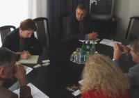
Talks of World Bank representative at DLAG MoARD and technical visit in a District Land Office in Budapest
From left to right: G.Apagyi, V.Stanley, A.Hodobay-Böröcz, P.Zalaba and A.Osskó at the WB-DLAG/MoARD talk. Image: HUNAGI Visual Resources

World Bank Operations Officer visited DLAG MoARD and the District Land Office at Lehel Square in Budapest on May 2, 2006
Ms. Victoria Stanley, Operations Officer for Europe and Central Asia Region- ECSSD at The World Bank visited the Department of Land Administration and Geoinformation, Ministry of Agriculture and Rural Development.
Ms. Stanley manages and works on several Land Administration projects in South
Eastern Europe financed by the World Bank. Hungary is seen as a model for land administration in the region and several of World Bank clients have visited the Hungarian Land Administration's institutions.
Her talks with the representatives of the DLAG MoARD and Capital Land Office focused on the Hungarian
- organizational model,
- relationship between property register and cadastre,
- financing (cost recovery, pricing, model using private bank loans etc),
- level of outsourcing (Cadastral mapping operated by the NKP Public benefit company including production of digital cadastre based on public procurement, as well as digital topo map database building),
- IT systems (property sheet database, TAKAROS the computerized procedures for District Land Offices, the Budapest project, the DLO/CLO intranet/extranet called TAKARNET having more than 4000 clients as on-line subscribers including novel applications supporting e.g. the location-based services via correction signal transmission of the active GPS network, the computerized procedure for County Land Offices called META and related EU Twinning inviting Austrian and British experts shaping the strategy for further developments. For the renewal of the digital cadastral/topographic databases aerial and space imageries are used. These imageries are primarily assist to implement the agricultural and environmental policies, improve disaster mitigation - an operational capacity available at the Institute of Geodesy, Cartography and Remote Sensing (FÖMI)
Involvement of the Land Administration and its institutions in the establishment of the spatial data infrastructure was also mentioned. All county level Land offices are members of the Hungarian spatial data interest community, an information network called HUNAGI.
The type and level of service delivery at one of the offices serving citizens was intoduced on the spot at the Lehel Square District level Land Office in Budapest.
The partners in the talk were on Hungarian side Deputy Head of the Department Mr. András Hodobay-Böröcz, former Director General Mr. Géza Apagyi, Ms. Piroska Zalaba (IT project manager), Mr.András Osskó, Deputy Head, Capital Land Office, and Dr. Gabor Remetey-Fülöpp former World Bank Project desk officer at DLAG MoARD. At the Lehel Square DLO Ms. Stanley was received by Mr.Dr. Zsolt Szabó, Head of the Capital Land Office, Head of the DLO and Mr. Gergely Szilvai IT expert.


0 Comments:
Post a Comment
<< Home