Hungary: EO/GNSS and the natural disater mitigation
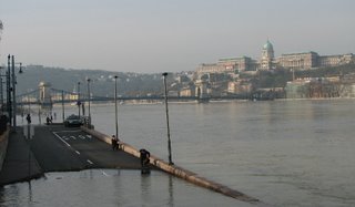
The cresting Danube at Budapest today. Photo taken on 5th April 2006 at 8 am. Image: HUNAGI Visual Resources.

Highwater in Hungary !
The major rivers in Hungary, namely the Danube and Tisza are expected to crest today with a highest ever-recorded level. The Danube bend is exceptionally heavely impacted: many of the villages are isolated by the highwater and experiences limited accessibility.
The use of earth observation and satellite positioning techniques and service capabilities developed during the previous decades available at FÖMI is expected to be highlighted by the opening speech of Dr. Norbert Berczi, Deputy State Secretary of MoARD at the opening of the CEOS WGISS & WGCV Meeting held in Budapest between 8-12 May 2006.
More on the CEOS Budapest events: http://www.eogeo.hu


0 Comments:
Post a Comment
<< Home